


Check out Carmageddon II detour maps
September 25, 2012
If you can't stay home, stay in the know and check out the Carmageddon II detour maps.
If you absolutely, positively must drive this weekend, here’s your road map for steering clear of trouble.
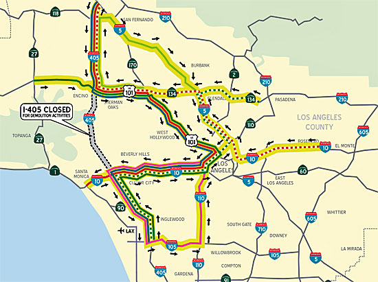
While there’s no official map of surface street routes for navigating Carmageddon II, Metro has produced maps showing how local and regional freeways will move around the construction zone.
Wherever you’re heading, your object should be to stay as far away as possible from the 405 Freeway, which will be closed from the 10 to the 101 on Saturday, Sept. 29 and Sunday, Sept. 30. Ramps will begin closing 7 p.m on Friday, Sept. 28, with full closure of the freeway in both directions beginning at midnight.
Things are set to reopen, after a full 53 hours of construction work, at 5 a.m. on Monday, Oct. 1. The work is needed to demolish the north side of the Mulholland Bridge, which will be torn down and rebuilt as part of a massive improvements project through the Sepulveda Pass.
The official mantra is stay close to home, patronize local businesses, savor your own neighborhood and give your car the weekend off. But if you have to drive, these maps will help guide you around the project zone and Southern California as a whole.
For a closer look at the northbound closure zone, click here. The southbound details are mapped out here.
Posted 9/25/12


 405 bridge work causes a stink