


Here’s a car-free route to the beach
February 22, 2013
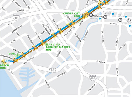
Detail of CicLAvia map released this week shows a straight shot to the shore.
However you roll, you won’t want to miss the next CicLAvia, which blazes a new trail through the Westside before culminating at Venice Beach.
The map for the April CicLAvia was released this week, showcasing the event’s longest route so far, stretching about 15 ¼ miles between City Hall and Venice Beach. It follows Venice Boulevard most of the way, although there are shorter stretches on Figueroa, Main and 2nd streets downtown.
Since 2010, the popular bike and pedestrian events have reached out to new communities while opening up some of L.A.’s streets for healthy car-free fun. This is CicLAvia’s deepest foray yet into the Westside.
The moveable street party runs from 10 a.m. to 3 p.m. on Sunday, April 21.
CicLAvia “hubs”—providing meet-up places and pit stops for refreshments, relaxation, and bike repairs—will be located at El Pueblo, City Hall, Normandie Avenue and along Venice Boulevard in the Fairfax District, Culver City, the Mar Vista Farmers’ Market, near Abbot Kinney and at the beach .
Posted 2/22/13


 405 bridge work causes a stink

