


Start mapping your 405 getaway
July 8, 2011
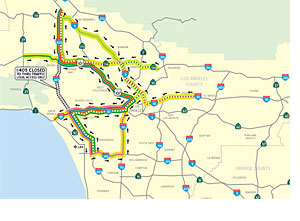 The latest ramp closure and detour maps for the 53-hour shutdown of the 405 Freeway have been finalized and feature a Sepulveda Boulevard route through the closure zone that will be designated for locals only.
The four maps include a regional overview showing how the closure will affect freeways throughout Los Angeles County, up-close views of specific ramp closures (one for the northbound freeway and the other for the southbound) along with a detour map indicating recommended routes around the segment of the 405 that will be closed so workers can demolish the south side of the Mulholland Bridge over the freeway.
Notably, Sepulveda Boulevard between the 10 and 101 Freeways is marked as being closed to through traffic and will be designated as reserved for local access only, according to the draft map. However, Ron Macias, a community relations officer for the project, said there are no plans to check IDs to ensure that only residents are using the street. “We cannot prevent anyone from using Sepulveda, but it’s going to be gridlocked,” he said, noting that Metro is strongly encouraging motorists to stay far away from the area.
Ramps will begin closing around 7 p.m. on Friday, July 15. The entire freeway will be closed all of Saturday, July 16, and Sunday, July 17. It is expected to be reopened by 5 a.m. on Monday, July 18.
Posted 6/2/11


 405 bridge work causes a stink