Coasts & Mountains
The big chill
August 11, 2010
It’s been a long cold summer.
Whether the record-setting chill of July and early August makes this L.A.’s best or worst summer depends a lot on where you live—and a little on what you value most in the season. While waiters in Venice have had to hand out blankets to rooftop lounge patrons, kids in Sylmar have been able to frolic in an unusually temperate county park.
Hotter weather is expected this weekend—finally—and there are a lot of potentially scorching days yet to be logged before the sun sets on the summer of 2010. But what’s happened so far is unusual enough that the National Weather Service was moved to put out a statement Wednesday headlined, “What has happened to summer in Southern California?”
(The answer, in short, is that an upper level offshore trough—the kind that usually shows up in the fall or winter—has decided to park itself off the West Coast for the last 2 1/2 months.)
The ensuing, and seemingly endless, June gloom has led to some stunning temperature readings.
The average temperature of 65.7 degrees at LAX tied the record for the coldest July on the books since statistics started being kept in 1944, the weather service said. (July of 2010 shares the distinction with 1948 and 1965.) The high of 65 degrees logged at the airport on July 8, the weather service noted, “would be below normal even for January!”
With the weather service using exclamation points to underscore the drama of the situation, it’s no surprise that the coastline chill has led to some national media attention.
At Venice’s Hotel Erwin, waiters have had to hand out blankets and crank up heaters at the High Rooftop Lounge.
Even with such amenities, business is off as fewer patrons brave the uncharacteristically cool elements to enjoy 360-degree views from the hotel, which overlooks Muscle Beach.
“I’ve worked at outdoor restaurants for 6 years and I’ve never seen anything like this,” said Tiffany McClintock, a food and beverage manager at the High, as she calls it. “The weather has had a huge impact…We expect June gloom, but it’s August and usually we have summer by now.”
Although summer has been pretty much a bust for bronzing (which isn’t good for you anyway), it’s been a boon on the green side of things because power usage has dropped along with temperatures. The Los Angeles Department of Water and Power says that, since July 1, customers have been using 5.2% less than the department had forecast.
That’s a lot fewer air conditioners being cranked up.
“In cooler weather, there’s reduced demand for power, and that’s what we’re seeing,” said Michael Cockayne, supervisor of load forecasting at DWP.
A really hot summer day will demand 5,500-5,700 megawatts, he says. On Wednesday afternoon, the peak load was at about 3,830 megawatts.
“That’s very low,” he said,
Cockayne warns that no one should get too complacent, however. Peak power use days typically begin in earnest about the middle of August. “It’s a pretty good chance that we’ll see more peak days between August 15 and September 15,” he said.
So far this summer, though, the cooler weather has meant a break for lifeguards at county beaches, who’ve performed 3,050 rescues since June 1—compared to 6,745 in the same period last year.
Overall beach attendance is down, too, to just over 13 million visits in July. That’s well below the 18.9 million visits last July, but above the month’s average of 12.4 since 2000.
The cool summer has also offered a break to the elderly.
One measure of that is the fact that cooling centers have had to be activated only once this summer, notes Ellie Wolfe, manager of internal services for the county’s Community and Senior Services Department.
“I’m loving it,” Wolfe said. “It’s been a much safer and saner summer—so far.”
Kids attending summer camp at the county’s El Cariso Park in Sylmar have been enjoying cooler-than-usual days for field trips and park activities. “It’s been a whole lot nicer than last summer,” said Sandra Chapman, the park’s recreation supervisor.
At the El Cariso pool, the usually sweltering deck has stayed cooler this summer, to the delight of sunbathers. “People seem to love it because the weather is, like, perfect,” said pool manager Mike Baham. As for the lifeguards, “none of ‘em got burned this year.”
National Weather Service meteorologist Jamie Meier, stationed in Oxnard, hears it from both sides of the hot and cold debate.
“I get mixed reviews,” she said. Her family, living on the Westside, tells her: “Our air conditioning bill has been fantastic.” But a friend visiting from Texas was not so enthusiastic, summing up her feelings with a simple: “California is cold!”
Posted 8/11/10
A new way to dam pollution
June 23, 2010
In a bid to improve water quality at a popular beach, Los Angeles County Public Works engineers will deploy an unusual weapon: a large, inflatable rubber dam.
The device, measuring 37 feet long and 4 feet high when inflated, will be used during the dry season in the Santa Monica Canyon storm drain to keep dirty water from flowing into the ocean at Will Rogers State Beach. The result, according to Bruce Hamamoto of the Department of Public Works: “There will be less bacteria at the beach.”
The rubber dam, scheduled to be installed in 2011, will replace an existing system that sends bacteria-laden water through sewers and into the City of Los Angeles’ Hyperion treatment plant near LAX, where harmful bacteria are removed. The new system will give water officials more flexibility to increase the amount of dirty water diverted to Hyperion.
Although rubber dams have been used by the county to help manage groundwater storage, this is the first use of a large dam along the coast to fight water pollution. (A small rubber dam was installed at the new Marie Canyon facility in Malibu last year.)
The rubber dam, essentially an inch-thick inner tube, allows officials to capture dirty water that would, on occasion, breach an existing 15-inch concrete dam, built in 2003. Now, when the water gets higher, the rubber dam can be inflated up to four feet high to divert more of the flow to Hyperion. Conversely, officials can deflate the rubber dam during storms to send water directly into the ocean and avoid flooding.
The $2 million dam, approved by the Board of Supervisors last month, represents the county’s portion of a joint project with the City of Los Angeles. The city will spend $6 million to double the size of the pipes that divert water through the sewers to Hyperion.
The dam project is part of a broader county effort to improve water quality at L.A.’s beaches by bringing pollution levels below those set by state environmental regulators.
More than 3 million gallons of water flow through the Santa Monica Canyon Channel on the average “dry season” day. Much of the water comes from the irrigation of lawns and gardens across a 10,000-acre swath of the Westside.
Post 6/23/10
Magnificent milestone in the mountains
June 9, 2010
Chalk up another win for the green team. After years of fending off development that could have overwhelmed its oak-studded slopes with condos, shopping centers or a massive megaplex, a spectacular swath of the Santa Monica Mountains can finally rest easy.
It’s now public land—to be preserved for posterity in its natural state.
The $6.25 million acquisition caps more than a decade of efforts by a coalition of government officials, environmentalists and activists seeking to preserve the nearly 200-acre property as an important wildlife corridor and plant habitat.
But the significance of the land—a rustic spread that once belonged to entertainment legend Bob Hope—goes well beyond its environmental value.
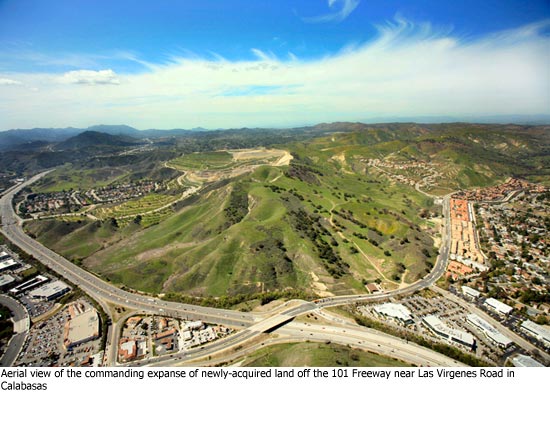
It also serves as an unofficial gateway to the Santa Monica Mountains National Recreation Area, visible to the 184,000 motorists who pass each day on the 101 Freeway as a symbol of the wilderness that still exists at the city’s edge.
“It’s just so special,” said Los Angeles real estate legend Fred Sands, who recently agreed to sell the property to the Mountains Recreation and Conservation Authority. “I’ve walked that property and I’ve hiked it. I’ve taken people there and their jaws dropped.”
Sands, who now is involved with commercial real estate ventures involving shopping centers and malls and also has a private equity firm, said he had considered building a horse ranch for his daughter on the property. He also mulled building a shopping center or keeping the land in a family trust and eventually constructing houses there.
He said the time he’d spent on the property changed his mind. “It’s the right thing to do,” he said. “The more I thought about it, the more I thought it shouldn’t be developed. This is just too beautiful.”
He said he’d considered hanging onto the property because it was worth more than he was being paid. But, he said, “I’m not exactly penniless. Not everything has to be about money…There’s a tax advantage. But I don’t need it for the tax advantages.”
“It’s about doing something for the public, and for the future.”
It is ironic but also fitting that the purchase of that scenic expanse is being bankrolled by, well, garbage. Specifically, the land was purchased, in part, with fees charged to hauling companies that use the Calabasas Landfill, along with money from a “gas-to-energy” program there.
 Now that it belongs to the Mountains Recreation and Conservation Authority—a partnership among the Santa Monica Mountains Conservancy, the Conejo Recreation and Park District and the Rancho Simi Recreation and Park District—the agency will maintain the rustic site and open it up to the public starting Saturday, when the property is set to be dedicated.
Dash Stolarz, a spokeswoman for the MRCA, said that crews were busily clearing brush from a ranch road that runs through the property. Parking is—and will remain—on a dirt lot. “We’re not going to develop it in any way,” she said.
Melanie Beck, an outdoor recreation planner for the National Parks Service, whose land borders the property, said the property will form an important link in the Las Virgenes Creek Trail, which is part of a larger loop called the Calabasas Cold Creek Trail. “I think it’s one of the most important acquisitions that the agencies have taken on in the last few years,” Beck said, noting the “visual relief” it provides for motorists leaving the San Fernando Valley.
Sands bought the property after the previous owner, Robert Zuckerman, was thwarted in his plans to build condominiums and a massive retail center on the land, complete with a 3,600-seat movie theater complex. Zuckerman’s proposal drew the ire of environmentalists and Supervisor Zev Yaroslavsky, and eventually fell apart after the county rejected his building plans.
Yaroslavsky said that Zuckerman had taken him on a tour of the property when he was seeking approval to build. “That was the biggest mistake he could have made,” Yaroslavsky said. “My first look at the dozens of mature oak trees and the pristine nature of the property convinced me on the spot that the property should be part of the Santa Monica Mountains park system.”
He said that after Sands bought the property, he inquired whether Yaroslavsky’s office would support any zoning changes to allow development on the land beyond the small number of homes that would have been permitted under current zoning. The answer was no.
Several years ago, Yaroslavsky approached Sands about selling the property to the MRCA. The agreement came together in the last 60 days.
The property is known to some as Firehouse Hill, a nod to the nearby Los Angeles County Fire Station 125. Others call it “Continental Communities”—a reference to Zuckerman’s ill-fated development plans.
Whatever you call it, the property ranks as the most significant acquisition since the former King Gillette Ranch, which the MRCA opened to the public in 2007. Since Yaroslavsky took office in 1994, almost 23,000 acres in the Santa Monica Mountains have been acquired and set aside as open space.
“We’ve saved a lot of big pieces, but it’s like pieces of a mosaic,” said Dave Brown, a community activist who’s been prominent in the efforts to preserve open space in the mountains. “You have to make sure there won’t be people coming in with inappropriate development plans.”
On the newly-acquired Calabasas property, that’s no longer an issue—to the relief of those, like Brown, who have worried about what might end up on this piece of land that exerts such a strong pull on those who’ve seen it.
“I’ve discovered over many years of living here that many people are emotionally attached to this property,” said Brown, who also is an appointee to the advisory committee of the Santa Monica Mountains Conservancy. “It tells people that they’re in a new area—an unspoiled natural area.”
Watch our video, “Santa Monica Mountains: An Island of Nature,” and read Zev’s blog about the remarkable strides that have taken place to preserve open space in the mountains.
Posted 6/9/2010
More L.A. beaches acing their tests
May 27, 2010
The grades are in, and water quality at Los Angeles County beaches improved significantly last year, according to environmental watchdog Heal the Bay’s statewide 2009-10 Beach Report Card.
 The latest report, released this week, gives 79 percent of the county’s beaches an A or B grade during the dry-weather summer season, up significantly from last year’s 70 percent and from the six-year average of 73 percent. The report uses a complex scorecard based on weekly measurements of bacterial pollution between March 2009 and April 2010 at 326 California beaches, including 86 in L.A. County.
Heal the Bay President Mark Gold says the improved grades are the result of efforts to clean up water runoff from streams and storm drains. “These pollution cleanup projects are beginning to pay dividends,” he said.
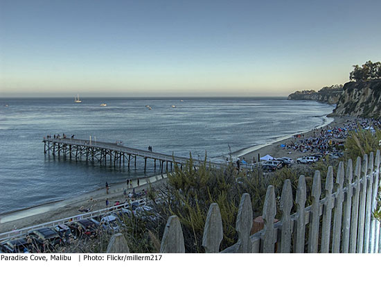
Failing grades at two troubled Malibu beaches last year jumped to B’s this time, thanks to recently-installed cleanup systems. A county Department of Public Works project at Marie Canyon launched in late 2007 zaps bacteria-tainted water with ultra-violet radiation before returning it to the creek that empties into the ocean at Puerco Beach. At Paradise Cove, the cleaner flows correspond with the completion of new privately-owned sewer and waste water treatment systems.
Despite the good news, Los Angeles County’s overall water quality remains the worst in California. Seven local beaches earned an F in year-round testing—down from 15 last year, but still troubling, Gold said.
Five local beaches made the group’s “Beach Bummers” list of the worst summer-season spots. The bummers include beaches at Avalon Harbor Beach on Catalina; Cabrillo Beach in San Pedro; Santa Monica Pier; Colorado Lagoon in Long Beach; and Sunset Boulevard and Pacific Coast Highway in Pacific Palisades.
Even with cleaner beaches, Gold counsels swimmers to stay out of water near creek mouths or storm drains. “If it’s an open-ocean beach, it’s a clean beach,” Gold said.
For Heal the Bay’s press release on L.A. region beaches, click here.
Posted 5/27/10
Testing for toxics at the Marina
March 18, 2010
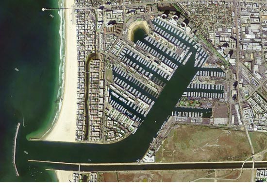
It’s the largest man-made small-boat harbor in the United States—and it’s about to see the launch of a new project to measure toxic pollution.
The harbor at Marina del Rey is home to over 4,000 motor craft and sailboats. Built on former wetlands at the mouth of Ballona Creek by the Army Corps of Engineers, the Marina opened in the summer of 1965.
Hotels, condos, parks and restaurants sprang up around the giant marina on county unincorporated land. Beyond the Chris-Crafts and cruising yawls, the marina boasts a sandy “Mother’s Beach” that’s a favorite for wading and swimming because it’s protected from the ocean’s waves.
But the marina also has a history of elevated levels of five toxic substances, landing the man-made harbor on a list of “impaired” waterways under the federal Clean Water Act, along with thousands of polluted lakes, rivers, harbors and estuaries around the nation.
As a key preliminary step to a cleanup, the Board of Supervisors approved a plan this week to team up with the City of Los Angeles and Culver City to pay for a three-year, $4.5 million monitoring regimen for the toxics in waters and sediments of the harbor and in the storm water drains that flow into the marina.
“The first three years we’ll develop a baseline to find out what the levels [of the pollutants] are currently,” said Oliver Galang, a senior civil engineer at the Department of Public Works, who will head up the toxics monitoring project.
Galang’s team will then guide the formation of a cleanup plan for any toxics that remain unacceptably high. The aim is to bring all inflows of the toxics under acceptable levels for swimming and other recreational uses by 2016.
By July, Galang hopes to get monitoring underway in the man-made 2.9 square mile watershed that includes the Marina, parts of Venice and a small slice of Culver City.
Three of the toxics found in elevated levels are metals: copper, lead and zinc. Galang says that they come largely from automobile brake pads that shed minute amounts of copper and zinc onto the streets, where they are flushed into the storm drains and into the water. The lead sources may range from discarded industrial supplies, batteries or residues washed from old lead-based paint, he says.
Also to be measured are two long-banned organic compounds found in harbor sediments in the 1990s. Chlordane was a pesticide sold until the early 1980s; PCBs, or polychlorinated biphenyls, were found in paints, plastics and electrical equipment until 1979.
Past monitoring showed that the bulk of the toxics sat in mucky sediments at the harbor’s bottom, not suspended in the water itself. County health officials say they can’t make a definitive statement on the presence of the toxics and any potential health issues without further data.
Once underway, data technicians will take monthly water samples in the harbor and in the storm drains as well as analyze chemicals in sediments beneath the harbor. Divers will capture fish and mussels to check for buildup of toxics in the animals’ tissue. They’ll also gather and analyze water during winter storms.
Most of the toxic pollutants found in the past lurked in the sediments of the back basin, the inland edge of the harbor.
“The back basin doesn’t have a lot of water circulation,” Galang said “The tide doesn’t flush it out very well.”
The toxics plan is the second pollution fix to be undertaken at the harbor. An earlier plan aims to cut levels of harmful bacteria, but it ran into trouble when state regulators reported last month that bacterial counts exceeded limits 186 times between 2007 and 2009.
In February, the state’s Regional Water Quality Control Board staff proposed levying nearly $275,000 in civil administrative fines against the county’s Flood Control District, which built diversions to carry water to sewage treatment. In its complaint, the state held that the district alone was responsible for the high bacteria counts—but not the city of L.A., where the dirty water originated.
Public Works officials have called the proposed fines “irresponsible and counterproductive” and asked the state to “rethink” them. The full Regional Water Quality Control Board will consider the fines at their May meeting.
The county Department of Public Health closely monitors the presence of harmful bacteria in the waters. Public warnings about bacterial counts were reduced significantly when the county recently installed underwater propellers to improve circulation along the marina beachfront, said Beaches and Harbors Department Director Santos Kreimann.
On the toxics plan, the county’s Galang said the upcoming measurements will help water specialists to fashion solutions that the county and its partners will present to the state regulators next spring.
3/18/10
A green legacy grows in the mountains
December 1, 2009

You could call it a microcosm of the Southern California landscape—but there’s nothing “micro” about the Santa Monica Mountains National Recreation Area.
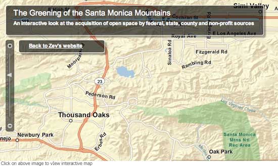
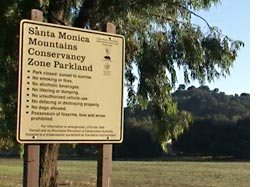 Covering 153,075 acres—more than 83,000 of them preserved as parkland and open space—the area draws millions of visitors each year to its seven state parks, campgrounds and hiking trails. To get a sense of its scope, consider these superlatives from the National Park Service: Not only is it the “world’s largest urban national park,” it has “more area codes (5) and zip codes (26), including the notable 90210 zip code of Beverly Hills, than any other unit in the National Park System.”
Strategic acquisitions of land—mostly in the Third District—by a coalition of local, state and federal agencies during the past 20 years have played a transformative role in shaping the recreation area into an ever-growing expanse of green. Just this fall, the National Park Service closed escrow on several parcels of land, totaling 117 acres, in Upper Solstice Canyon. The canyon—described by national parks officials as a “pristine 2,863-acre coastal watershed”—is home to waterfalls, creeks and 25 species of rare and endangered plants and animals.
To sample the rustic beauty of the recreation area and meet some of its dedicated advocates, click on the video above. And check out our interactive map to see how the green areas have expanded over the course of a generation.
State parks to remain fully open, thanks to friendly feds
November 23, 2009
The National Parks Service has come to the rescue of the highly popular state parks in the Santa Monica Mountains, providing a grant of $939,169 to avoid cutbacks that would have been likely because of Sacramento’s budget shortfall.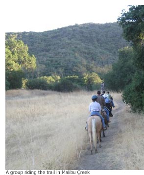
The state has seven parks in the Santa Monica Mountains area—including Leo Carrillo, Topanga, Will Rogers, Point Dume and Malibu Lagoon—with campgrounds at Leo Carrillo, Malibu Creek, Point Mugu and Thornhill Broom. About 3 to 4 million people visit each year.
“As a result of this grant, the public should experience no reduction in services or operating hours when they visit the many beautiful state parks and beaches within the national recreation area,” Woody Smeck, superintendent of the Santa Monica Mountains National Recreation Area, said in an e-mail to State Senator Fran Pavley and Assembly Member Julia Brownley.
“We’re just pleased that we can bridge the gap,” Smeck said later in an interview. “This grant is really an investment in maintaining a good national-state park system here in Southern California.”
The grant, made to the Angeles District of California State Parks, was issued Friday.
Without the infusion of funds, state parks officials would have had to reduce services, said Ron Schafer, district superintendent of the Angeles District, California State Parks. “It could have been significant,” he said pointing to a laundry list of “usual suspects”—ranging from bathroom closures at campgrounds to reduced hours and seasonal closings.
Supervisor Zev Yaroslavsky, whose district includes the Santa Monica Mountains, said he was thrilled by the level of intergovernmental cooperation that clearly is accruing to the public’s benefit.
“Protecting and operating these precious parklands is a cooperative venture, and no level of government can do it alone,” the supervisor said. “In light of the dire fiscal situation in Sacramento, I’m very grateful that Washington was able and willing to step in and assist us this year for the benefit of the public.”
Assembly member Brownley agreed.
“The NPS stepping up in this very significant way is just one more example of the extraordinary working partnerships we have among the various park agencies. I don’t ever want to see a single one of our precious state parks or beaches closed to the public. We are the stewards of these unique resources and have an obligation to protect and preserve them, not to shutter them. I can’t say enough to express my gratitude to the NPS for this wonderful gift.”
The national parks service is not only acting to benefit users of the state parks—there’s also an element of self-interest, Smeck said.
Because the state and national parks are “interlocking,” any notion of closing the state parks for, say, one day a week or for an entire month at a stretch, would have presented difficulties for his staff, Smeck said. Boundaries are porous, and fire safety would have been an issue in an unattended park. In addition, the burden of any search and rescues would have fallen upon the national parks service.
“As the nearest emergency responder and provider of park programs,” Smeck said in his e-mail, “the National Park Service would have directly felt the consequence of state park service reductions.
A creek runs through it
October 30, 2009
Bringing a creek back to life isn’t a job – it’s a commitment for all seasons.
And for the biologists, environmentalists and volunteers who’ve made it their mission to restore Topanga Creek, removing 26,000 tons of concrete and debris last year was just the beginning.
This fall, they’ve moved into planting mode, laying the groundwork—literally—for a rebirth of not just a creek but of an entire ecosystem.
The oaks, sycamores, cottonwoods and other California native plants are still going into the ground, but Rosi Dagit, the driving force behind the project, has seen enough to declare the process a success.“Beyond our wildest dreams, it worked,” says Dagit, senior conservation biologist with the Resource Conservation District of the Santa Monica Mountains. Dagit has spearheaded the creek restoration effort with a huge and varied array of supporting players that includes the Mountains Restoration Trust, the Temescal Canyon Association, TreePeople, the California Conservation Corps and a Sierra Club trail crew.
“It’s huge,” says Jo Kitz, co-executive director of the nonprofit Mountains Restoration Trust, praising Dagit’s tenacity. “I don’t know how many agencies she had to go through to get where we’ve gotten. Once it’s done, it’s just going be one of the brightest spots in the mountains.”
Although the project has been years in the making, progress has been dramatic lately. The first big test of the restoration effort came last winter, with the downpours of December.
Would Topanga Creek return to its natural flow, now that a 1,000-foot-long mound of debris had been leveled? Would the creek once again become a birth canal of sorts for endangered steelhead trout that once flourished in its waters?
Dagit and her team crossed their fingers, jumped in their cars and headed to the creek to see whether their carefully crafted plans would unfold in the natural world as they’d envisioned. They were awestruck.
“It was the coolest thing ever,” says Dagit. “We couldn’t cross the creek because the water level was so high. I was a little weepy.”
The massive project had, in fact, worked to send water racing again through a stretch of the creek that had been rendered largely dry by the concrete berm, originally built four decades ago to protect homes from canyon flood waters. Over the years, residents just kept piling it higher and higher. Tons of backed-up sediments from the berm had literally driven the stream underground. Over the course of the next few years, winter rains will continue the clean-up process, washing sediment out to the shore, Dagit says.
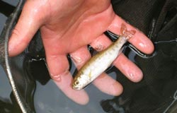
And the steelhead trout, which live in both fresh and salt water, will have a straight shot from creek to ocean—and a swimming chance to repopulate in far greater numbers. What’s more, new habitat has been created for other at-risk creatures, including pond turtles, two types of garter snakes, the California newt and an assortment of frogs.
In all, during three months last fall, 26,000 tons of dirt and debris were hauled away—all of it recycled except for 94 truckloads of hazardous soil. Native plants and trees were protected, and native lupines were planted. The total cost was about $3 million in government grants, including $450,000 from Supervisor Zev Yaroslavsky’s Third District funds.
Over the past year, monthly workdays have drawn volunteers to plant, water and weed. The Conservation Corps recently swooped in to pick up 30 tons of left-behind concrete and 10 tons of asphalt. A Sierra Club trail crew has chopped away invasive non-native plants like arundo.
“It’s an extremely big deal,” Ron Webster, leader of the Sierra Club’s Santa Monica Mountains trail crew, says of the project. “The creek is an incredibly important resource. It’s so rare to have a year-round creek running through the mountains and to the ocean.”
With the creek finally reconnected, the biologists are turning their attention not only to planting but to the progress of the steelhead trout.
Late last year, Dagit and her colleagues tagged 75 to 100 of the endangered fish to track their movements. An antennae was placed in the stream to register each time one of the tagged steelhead passed by on its way to or from Santa Monica Bay. (A warning to would-be poachers: there’s a $25,000 fine for removing steelhead from the creek.) This November, Dagit and her 10-person team are going to hand-capture fish and compare scale samples with those taken last year — an unprecedented way to document the age and growth rate of steelhead in this location.
Eventually, the heavy work of planting will be completed and the focus will shift to another huge undertaking: the clean-up of Topanga Lagoon. But there are moments, as the seasons march by, when Dagit can’t resist stopping to savor the satisfaction of all that’s already been accomplished.
“I actually can’t believe we really did this,” she says. “I’m still pinching myself.”
Not so much trouble in Paradise (Cove)
October 29, 2009
They set out to solve one mystery, but they ended up with another.
First, the good news: An unusual three-year research partnership has found that the water quality at Malibu’s Escondido and Paradise Cove beaches is dramatically better than expected. Now the puzzling news: Nobody knows why.
“It’s like you hired Scotland Yard to solve a murder and three weeks later the dead person walks in and says, ‘Whatcha doing?’ ” says Steve Weisberg, executive director of the Southern California Coastal Water Research Project, which is running the study with $800,000 in funding from Los Angeles County. “We were hired to find the source of the problem….Where we’re at is a point of frustration.”
When the project started in May, 2006, the targeted beaches stood out as significant problem areas, according to Mark Gold, president of Heal the Bay, which has participated in the research along with the county Department of Public Works.
“Escondido was the most polluted beach we had ever seen,” Gold says. On the group’s annual Beach Report Card, he says, “I think it got a zero one year.” (Now Escondido Creek, just east of Escondido State Beach, and Paradise Cove Pier at Ramirez Canyon Creek mouth are both on the group’s honor roll.)
Back then, Gold suspected that the pollution was coming from “illegal dumping of tremendous amounts of horse manure” and maybe also from waste discharge problems from a nearby restaurant and some mobile homes.
All this added up to an opportunity for some collaborative detective work, bringing together the county and its sometime-adversary Heal the Bay, which has pushed hard for more aggressive government enforcement of clean water regulations.
The Southern California Water Research Project was “brought in as a neutral party,” Weisberg says, adding that he thought the best way to achieve a détente was to have everyone in the field “taking samples together.”
At their disposal was an array of scientific tools – including tests for optical brighteners found in laundry detergent to learn if household wastewater was involved. (For more on those, click here.) Overall, the prospects for finally determining whodunit (or whatdunit) looked good.
“The problem,” Weisberg says, “is that we just have not found strong, recurrent problems at that beach.”
One theory holds that a series of unusually dry winters led to a temporary improvement in the bacteria levels flowing from Escondido and Ramirez creeks into the bay. Another scenario posits that someone was illegally dumping, found out about the study in progress and decided to clean up his or her act. Or maybe different testing methods yield a different result? “We don’t know,” Weisberg says, “but we know it stopped.”
Weisberg says the hunt will continue in the coming year, with some discussion of testing to determine whether “birds pooping on the beach” mighty be to blame for the pollution, rather than problems in the watershed.
Gold, for his part, thinks it’s probably not worth continuing the testing effort unless there’s significantly more rainfall this year, which would bring more runoff to analyze. He does, however, advocate keeping an eye on a restaurant at the “very lowest part of the watershed.”
“You never get to pack your bags and go home,” says Gold, who praises Supervisor Zev Yaroslavsky for responding to long-running concerns about the beaches’ bacteria levels and pushing for funds to study the problem. “I’m glad we did it,” Gold says. “I think it put a lot of people’s minds at ease.”
Mark Pestrella, deputy director of water resources for the county Department of Public Works, says he also is glad the study went forward and wants to see it continue for a fourth year. “The supervisors and the constituents out there really want to know that these beaches are safe,” Pestrella says.
“The study helped us set up protocols that were not in place before….Methods of sampling, the health department’s and Heal the Bay’s, were tried side by side,” he says. “It gave us more information on the percentage of the problem we should allocate to humans. Although we didn’t actually break down every source, we eliminated several areas. In Escondido, we were able to say we did not find a human source of indicator bacteria at the beach.”
The bottom line, Pestrella says, is that the study so far has “bettered the county’s understanding of how to monitor and test for indicator bacteria. It very much put science in front of rhetoric.”






 405 bridge work causes a stink
