


Top Story: Environment
A budding environmental menace
September 5, 2013
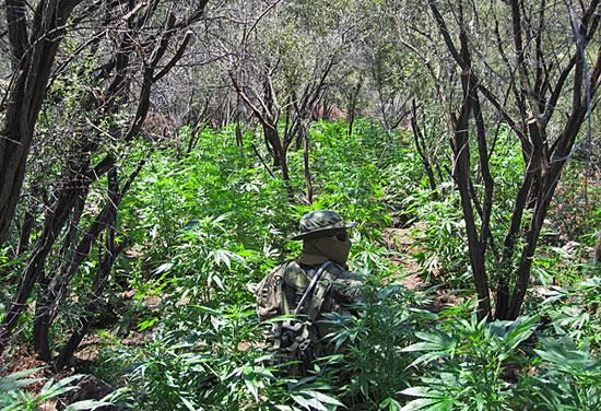
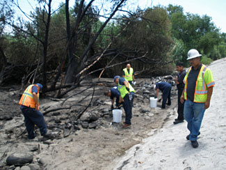
A member of an interagency enforcement team patrols a marijuana plot in Encinal Canyon. Photos/NPS
In the not-so-remote reaches of the Santa Monica Mountains, the scientists of the National Park Service are getting an unexpected and sometimes unnerving education in preserving the environment—and in protecting themselves. They’ve been forced to confront realities in the wild that could even make counting newts along a stream a risky affair.
Increasingly, park service researchers are sharing terrain with covert marijuana farmers who’ve exploited and wreaked alarming environmental damage on broad swaths of sensitive public lands as part of a multi-million-dollar trade possibly linked to Mexican cartels. With tightened security along the border, drug lords may have turned to the rugged mountains edging the L.A. basin for their cash crop.
Just last week, a pot farm was raided in Topanga State Park, one of the region’s most popular hiking destinations. Law enforcement authorities recovered 5,000 pounds of mature plants, worth an estimated $2.5 million, and removed 500 pounds of trash, camping gear and farming infrastructure. But that bust wasn’t even the largest in a series of seizures that have made headlines during the past few years, including some in the hills above Malibu.
Christy Brigham is no cop. But as chief of planning, science and resource management for the National Park Service in the Santa Monica Mountains National Recreation Area, she and her colleagues have learned to spot potential dangers and react to them, even if that means revamping long-planned research projects.
Tell-tale irrigation hosing discovered near a Santa Monica Mountains pot site.
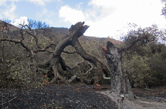
Take, for example, the red-legged frog. Brigham says the park service has been trying to reintroduce the endangered amphibian in streams across the Santa Monica Mountains. But a number of suitable sites, she says, were rejected because they had a high potential for pot farming or showed actual evidence of it, including the tell-tale black, flexible tubing that’s used to siphon stream water for irrigation of the illicit crops.
“If you had told me ten years ago that one of the things I would be doing is finding illegal marijuana gardens, I would have laughed,” Brigham says. “That’s not what I do. I’m a scientist. But you have to learn as a coping skill to identify the signs of illegal growing and respond appropriately. You try to get out of there as quickly and as quietly as possible.
“The even crazier part,” she adds, “is that not only are we identifying marijuana gardens but we’ve learned to quantify their environmental impacts so we can help the public understand how big a problem it really is.”
The damage is occurring across a number of fronts, Brigham explains, creating “a terrible ecological disruption” on lands that are supposed to be protected for public enjoyment and education.
Start with the water. Pot growers are damming low-running streams with rocks and siphoning the pooled water for distances that can stretch as far as a mile to hidden plots containing thousands of plants. Brigham says this may be endangering native stream creatures, including steel head trout, whose dwindling numbers environmental scientists have been working hard to reverse in the Santa Monica Mountains.
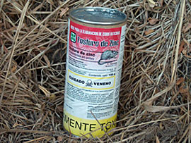
Poisons used by growers to protect plants from wildlife are jeopardizing such animals as bobcats.
Then there are the nitrogen-based fertilizers that foul the creek and the rat poison that growers deploy to protect their crops from hungry critters but that moves through the food chain, jeopardizing bobcats and other large mountain mammals.
Meanwhile, the streams are further damaged by the loose soil that flows into them after growers clear wide patches of native vegetation to plant rows of seeds. Brigham says the heavy silt in the water can fill the holes of native frogs and “suffocate” fish eggs dependent on clear, oxygenated water to develop.
But the most obvious environmental toll, Brigham says, comes from the growers themselves, who live at the sites and use the land as their trash can and toilet, which scientists believe could be one factor contributing to the high bacteria levels in the ocean at the mouth of Topanga Creek.
“It’s just horrible,” Brigham says. “It’s like having a dump in the park, which is not really what we’re working toward.” She says the makeshift camps also represent a danger to hikers—and those on her staff—who like to wander off-trail along the streams. Her advice: when you see those irrigation hoses, “it’s time to leave.”
Too often, Brigham says, news of big marijuana hauls on public lands seems to lead to a discussion about whether taxpayer money is being wasted by such law enforcement efforts. But she says there’s no arguing about the cost to the environment.
“Regardless of how you feel about whether marijuana should be legalized, that debate is completely irrelevant to the environmental issue,” Brigham says. “You’ve devoted your tax dollars and your attention to these parks. They are not farms. This completely disrupts the ecology of the area. It’s terrible.”
Posted 8/22/13
Smoke on the water
July 18, 2013
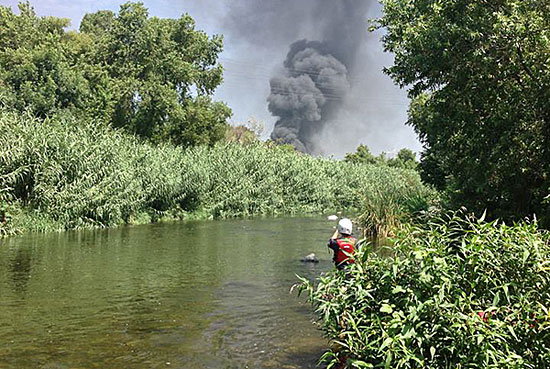
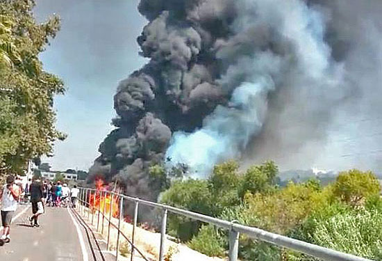
Smoke from Saturday's tanker crash, as seen from the river. Photo/Grove Pashley, L.A. River Kayak Safari
They’ve spotted swallowtail butterflies and hummingbirds, osprey and egrets, lizards and toads. They’ve glided by willow trees, eavesdropped on serenading coyotes, marveled at a hawk enjoying the catch of the day. But what they hadn’t experienced, until last Saturday, was a manmade inferno closing in on what’s rapidly becoming an unlikely recreational hot spot: The L.A. River.
Those who know the river most intimately—the folks who walk, fish or bicycle beside it, along with the hardy souls who take to its waters by kayak—were unnerved, to say the least, by the tanker truck crash Saturday morning in Elysian Valley that sent thousands of gallons of gasoline heading straight toward one of the river’s most popular stretches.
“We came around the bend and there was this huge fiery thing going on,” said Anthea Raymond of L.A. River Expeditions, who had just led a group of kayakers on a river trip Saturday morning and was returning by bicycle to their starting point, a newly-opened pilot recreation zone near Fletcher Drive. “It was a crazy situation because it was just so unusual. Who would have expected that the flames would be shooting through the sewers and blowing up manholes and blow-torching, basically, the foliage on the western side of the L.A. River?”
Amazingly, no one was hurt in the accident—and that includes, apparently, the river itself.
“It was a huge fire and we got really lucky on the environmental part,” said Andrew Hughan, a spokesman for the California Department of Fish and Wildlife. “We can say with very high certainty that no actual gasoline got into the river.”
The high flammability of the gas, the hot weather and a sandbar in the path of the spill added up to a “perfect storm of goodness” that kept the fuel out of the water, Hughan said. Contrary to some reports, he said, “the river itself was not on fire.”
He said, however, that “there is some particulate matter in the sandbar.”
“We’re leaving it there,” he added, saying that it would be more damaging to the environment to remove the material than to allow it to remain in place and let nature take its course.
HazMat workers on blackened river bank. Photo/California Department of Fish and Wildlife
Some gasoline also got into a massive storm drain near the crash site, which took place at the intersection of the 5 and 2 freeways and prompted major lane and tunnel closures. The city Bureau of Sanitation’s Watershed Protection Division brought in a team to flush things out. “The goal was to suck up all the product that was in the storm drain” with vacuum-equipped trucks, said Steve Pedersen, chief inspector for the division. The gas-and-water mixture was placed in a holding tank, to be hauled away after tests were completed.
Pedersen said contractors hired by the city have since inspected the storm drain “looking for sheen, looking for globules of oil,” and found none.
Lewis MacAdams, founder and president of Friends of the L.A. River, praised the emergency response to the accident but said the welter of official agencies responsible for the river at the federal, state and local levels shouldn’t be too hasty in declaring the situation resolved.
“When I was down there on Monday, there was a very strong smell of gasoline,” MacAdams said.
He said his organization will be watching the situation closely in hopes of ensuring that there is appropriate follow-through on the spill. “The whole idea was ‘We’ll just leave it the way it is because if we turn over the earth, that might disturb something else.’ I think it deserves to be looked at in more depth.”
Paradoxically, some river enthusiasts say that the brush with catastrophe may have been a good thing because of the public attention it has garnered for the waterway, which after decades as a gritty, concrete-lined expanse dedicated chiefly to flood control is experiencing a rebirth as a more natural and recreation-friendly environment. Some of the endeavors underway include a multimillion dollar L.A. River revitalization and bikeway project near Universal Studios, the North Valleyheart Riverwalk from Studio City to Sherman Oaks and the Los Angeles River Pilot Recreation Zone, which was inaugurated this spring, attracting hundreds of kayakers to the river where they can legally paddle for the first time in decades.
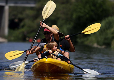
Kayakers on the L.A. River. Photo/Los Angeles Times
“It’s a moment when the way people look at the river and the way people use the river is changing,” MacAdams said. “People are now seeing things like the kayak trips…and suddenly that’s threatened by gasoline coming down the river. And people’s reaction is appalled and worried, rather than ‘Who cares?’ ”
The outpouring of concern has included a series of river photos and videos posted to social media showing the aftermath of the crash.
One video, shot by Grove Pashley of L.A. River Kayak Safari as he led a kayaking group on the river Saturday morning, juxtaposed the idyllic peace of the area known as Little Frog Rapids with images of menacing grey smoke straight out of an urban disaster movie.
“It’s just a really beautiful spot…Normally you hear birds, and all kinds of lovely wildlife in that area. And this particular trip, it was like, ‘Wow, I feel like we’re in a war zone’ because all of a sudden you had these helicopters above us,” Pashley said.
Another video, shot by Raymond, the L.A. River Expeditions kayaking guide, captured the hot orange flames visible from the river bikeway.
By mid-week, guides from both companies were eager to shrug off the drama and get back in the river, which has reopened for kayaking.
“There are still people who, of course, think the river’s dirty, who think it’s dangerous,” Raymond said. “Certainly on this stretch, neither of those things are true…The way to keep persuading those people is to show that people are back out here and we’re having a great time.”
“We did have to cancel a couple of trips, obviously, on Saturday and Sunday,” she added, “and those people are all rarin’ to go. All our trips are sold out.”
Flames and smoke along the river bikeway. Photo/Anthea Raymond, L.A. River Expeditions
Posted 7/17/13
When nine lives aren’t enough
June 20, 2013

Wildlife biologist Joanne Moriarty says fire adds yet another dimension to the stresses on the region's bobcats.
The sighting was unusual and upsetting. Just days after fire-ravaged Sycamore Canyon re-opened, worried hikers began to report seeing a bobcat sitting passively on a charred trail. Alarmingly skinny, she was not running away. Her whiskers were singed, and it was clear she’d had an earlier encounter with people. Her ears, they said, were tagged.
National Park Service officials, who’ve been tracking and studying bobcats in the Santa Monica Mountains for years, searched the canyon but couldn’t find the spotted cat. Then, earlier this month, a report came that left no uncertainty about the animal’s condition or location. A hiker found her dead a few miles beyond the Point Mugu State Park campgrounds, north of the Los Angeles County line.
Wildlife ecologist Joanne Moriarty of the park service says the bobcat’s entire “home range,” or habitat area, had been incinerated. “But the biggest thing was that her paws appeared to be burned. She couldn’t hunt or walk very well.”

This bobcat, its paws burned, would later be found dead by hikers as a result of the Springs fire in May.
The bobcat’s death, announced last Thursday on the Facebook page of the park service’s Santa Monica Mountains National Recreation Area, prompted an outpouring of comments lamenting the animal’s fate. One mountain biker, who’d seen the bobcat on the trail, said “it was the saddest thing to have to walk away from [her]. RIP beautiful cat.”
But the death also came with an irony for park service researchers—and a lesson for the broader public living in the region’s tinder-box conditions.
Several years ago, the bobcat—known simply as B274—had been captured, tagged and monitored with 16 others as part of control group for a landmark study of bobcats in the area’s more urbanized areas, such as Thousand Oaks and Westlake Village. There, the animals had been hit with an epidemic of potentially deadly mange. Researchers theorized that the cats’ immune systems had been compromised by eating rats poisoned with anti-coagulants, the most commonly used method of rodent control. Meanwhile, the control group, outfitted with GPS collars and living in the wilds, showed no evidence of mange or other immune problems.
But, in the end, bobcat B274—and probably many others—couldn’t be saved from another modern-day reality: An estimated 94 percent of wildfires in the Los Angeles region’s mountains are ignited not by nature but people acting carelessly, negligently or maliciously. “Even though these bobcats were in a much more natural area,” Moriarty says, “in reality they were still highly affected by human causes.”
According to investigators, the rampaging Springs fire, which came at an extraordinarily early time in the year, was accidentally caused by an “undetermined roadside ignition of grass and debris,” most likely from a passing vehicle.
Moriarty says that bobcats, which are solitary and territorial, are already stressed because their habitat has been sliced by roads and shrunken by developments. Now, with officials this week warning of fire conditions that look to be the worst in a century, she and other scientists worry that the toll on wildlife could be profound, especially with fires flaring earlier in the year because of worsening drought conditions.
Moriarty feels certain, for example, that bobcat kittens were killed in the Springs fire because it came during the “denning” season, when mothers are caring for litters of up to five kittens in the mountain underbrush. Of the 5-year-old bobcat found on the trail, Moriarty says, it’s “very possible she may have had kittens.”
And this, of course, raises broader concerns about survivability. “Anything that affects reproductive timing has huge impacts on a population’s ability to exist,” says biologist Laurel Serieys, who’s been collaborating with the National Park Service on bobcat research and runs a website called Urban Carnivores. “Human impacts on the environment and the wildlife extend far beyond the city boundaries.”
Exactly how many bobcats survived the wind-driven flames that hop-scotched through Sycamore Canyon is unknown. “Definitely, some of them are going to end up perishing,” Moriarty says. Budget permitting, she says, she’d like to set up remote cameras to track possible survivors and document the challenges they’ll surely face.
“As a person, it makes me sad,” Moriarty says of the likely bobcat deaths. “But as a scientist I find it interesting. We’ll have an opportunity to learn how even those who managed to escape are still going to be negatively impacted by the fire.”

National Park Service officials have undertaken the largest study ever of bobcats, monitoring them in the Santa Monica Mountains with GPS collars. Photo/Pete Padilla
Posted 6/20/2013
Lowering the heat on bonfire dispute
June 5, 2013

A shift in direction by air quality officials could keep fires burning on Dockweiler State Beach. Photo/L.A. Times
A hotly contested proposal to ban wood burning in Southern California’s iconic beach fire rings appears to be going up in smoke.
An official with the South Coast Air Quality Management District said in an interview on Wednesday that “an alternative proposal” had been developed that would continue to allow bonfires on the region’s beaches so long as certain measures were undertaken by June, 2014, to minimize the known harmful effects of burning wood.
“From our standpoint, we have better and more information than we had two months ago,” said AQMD project manager Tracy Goss. “A one-size-fits-all doesn’t necessarily apply in this case.”
And that’s good news for the popular pits at Dockweiler State Beach, which, under the earlier proposal, would have fallen victim to a dispute flaring 50 miles south, where Newport Beach officials are determined to remove 60 fire rings. Some residents there have complained of respiratory problems and smoke-drenched homes. At Dockweiler, the neighbors include LAX, a sewage treatment plant and an oil refinery, and they’re not complaining.
Restricting fires at Dockweiler for health reasons “doesn’t make a whole lot of sense,” Goss acknowledged, noting that the latest proposal would take a more nuanced beach-by-beach approach based on such things as topography, wind and proximity to homes. Goss declined to provide specifics until the plan’s public release, scheduled for Thursday. Already, the agency has two “public consultation meetings” set for next week on the new proposed amendments to Rule 444, which regulates “open burning.”
Of the national attention the AQMD’s earlier proposal attracted, Goss, a 25-year veteran of the agency, said: “When they make a political cartoon of your issue, that doesn’t happen very often.”
Kerry Silverstrom, chief deputy director of L.A. County’s Department of Beaches and Harbors, welcomed the news that Dockweiler’s fire pits will likely be spared. “We’re delighted,” she said. But she questioned why they were ever at risk. “On the scale of what’s bad for us,” she said, “fire rings at Dockweiler wouldn’t be the first thing I’d be talking about.”
She said the concrete rings have been there since at least the mid-1970s, when the county began running the beach at the foot of Imperial Highway. As much as 43 percent of Dockweiler’s annual parking revenues, or $570,000, comes from fees after 4 p.m., Silverstrom said—clear evidence of the popularity of the rings. “They provide a low cost recreational opportunity for a diverse population,” she said. “We see it as an access issue.”
So did the staff of the California Coastal Commission when, in February, it recommended denying Newport Beach a permit to remove fire pits that the mayor and city council contended were jeopardizing residents’ health. (Critics accused homeowners of simply trying to discourage undesirable outsiders from flocking to their affluent neighborhood.)
The commission staff stated that the removal of the rings would “deny the public access to this popular form of lower cost public recreation.” It also said the city had failed to demonstrate that the rings were “directly responsible” for health problems.
It was around this time that the AQMD entered the fray at the urging of board chairman William Burke, who also sat on the Coastal Commission—a job from which he’d resign as questions arose in Sacramento over a potential conflict between his positions on two agencies at odds with each other.
More specifically, Burke’s departure came after he said during an AQMD meeting in February that a nighttime aerial picture of the Newport fire rings reminded him of “carpet bombing” in Viet Nam, where he’d served in the armed forces. “This is Viet Nam revisited,” Burke said, but then quickly added: “Now it’s not really that bad because Viet Nam was horrible.”
As the AQMD continued to push for a regional ban, other cities pushed back, most notably Huntington Beach, which said its fire rings were a source of pride and commerce; they help “surf city” reap $1 million annually in parking revenues.
On Tuesday, the city’s community relations officer, Laurie Frymire, appeared before members of the Los Angeles County Board of Supervisors. “Our fire rings have been enjoyed for more than 60 years by folks from all over,” Frymire said, as she thanked supervisors for passing a motion by Don Knabe, whose 4th District includes Dockweiler Beach. The motion called on the board to oppose any action by the AQMD to ban fire rings region-wide and to leave such decisions to local jurisdictions. The Orange County Board of Supervisors, among other local government bodies, had earlier passed similar measures.
Now, given the shift in position by the AQMD staff, it looks increasingly likely that, at least in L.A. County, fire pits will no longer be a burning issue.
Posted 6/5/13
Burning questions
May 9, 2013
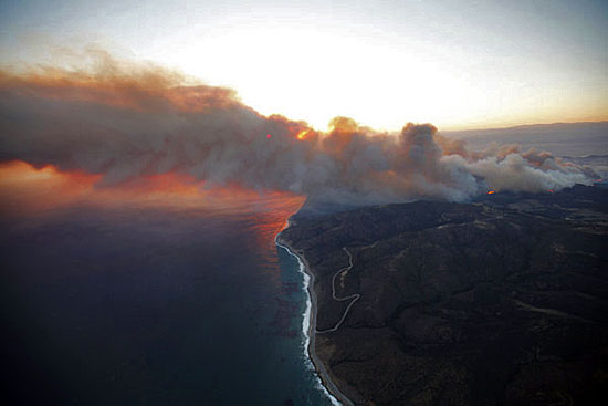
The Springs fire has left a trail of destruction—and ecological uncertainty—in Sycamore Canyon.
When wind-driven flames tore through one of the Santa Monica Mountains’ most scenic canyons last week, hearts sank with visions of another city escape transformed into a smoldering moonscape.
Sycamore Canyon draws thousands of visitors every month with its gorgeous vistas, canopied trees and a network of trails suitable for everyone from strolling couples to hardcore hikers. So the big question was this: exactly how destructive was the fire that ignited near Newbury Park in the inland valley and didn’t stop until it reached the sea at Point Mugu State Park, about 30 miles north of Santa Monica?
Over the past couple of days, some answers—along with new questions—have emerged, as national and state parks experts have hit the charred ground to begin investigating the fallout from the only spring wildfire in anyone’s memory.
What they’ve found might be good news for people eager for a return to the trails but troublesome for the area’s wildlife, especially its birds, now in their prime nesting season. “Normally, with fall fires, that’s not going on,” said fire ecologist Marti Witter of the National Park Service. “There was probably a significant hit to bird populations.”
The rare early timing of the so-called Springs fire also has raised questions about the regenerative resilience of burned trees, which were in their spring growth period and already were challenged by drought conditions. Deciduous trees, such as the sycamores, had yet to begin moving nutrients from their leaves to their trunks, as they do during the late summer and fall months. Those leaves are now scorched or incinerated. At a minimum, experts predict that damaged trees could remain leafless and unsightly for months longer than if the blaze had erupted later in the year during the normal fire season, when subsequent wetter months help force new growth.
“People are going to be looking at a black landscape much longer than they normally would,” said Witter, of the park service’s Santa Monica Mountains National Recreation Area.

Sycamore Canyon remains off-limits to hikers.
For now, the public won’t be seeing anything; officials have ordered a two-week closure of the Sycamore Canyon Trail area until an assessment of the potential dangers can be determined. A key player in that process is National Park Service plant ecologist John Tiszler, who, like Witter, also works in the Santa Monica Mountains National Recreation Area. Earlier this week, he toured the popular lower canyon on behalf of Ventura County fire officials.
“Clearly, the vast majority of it burned,” Tiszler said. “I know people are very worried about this but I don’t think there’s any reason to think that a catastrophe has occurred.”
Tiszler said “the fickleness of the winds” had left some spots unscathed as the flames quickly shifted through the broad lower canyon beyond the undamaged Point Mugu campground. Those scattered green zones, he said, could provide refuge for displaced, nesting birds and such ground wildlife as lizards, which park service staffers are attempting to rescue. (Click here for a satellite image of the “burn scar.”)
Tiszler said that, in the lower canyon, he flagged only 15 sycamores and oaks that had the potential to fall along the fire-road trail. Only three or four of them, he said, should be taken down. But in the canyon’s upper, narrower passages, he said, the toll appears worse because of more intense flames and heat.
The staying power of all those affected trees could be tested in the days ahead, Tiszler said, when high winds are expected to whip through the area again. He also said a looser standard will be applied to damaged trees along hiking trails that don’t have gathering areas, where the public might linger and be at greater risk. “If there’s no person, car or picnic table,” he said, “then the potential of being a public hazard is much reduced.”
Tiszler also noted that trees in Sycamore Canyon had withstood a number of blazes over the decades, including the more devastating Green Meadow fire in 1993. “Trees are like alien beings from another planet,” he said. “They are so different from us, the way they heal themselves, what they tolerate.” He said trees can stand strong even with deep hollows burned into their core because their weight is borne by their outer rings.
Like many veteran hikers and naturalists, Ron Webster of the Sierra Club does not view flames as an enemy of Sycamore Canyon’s trails, a good number of which he helped cut years ago. “You know, it’s just fire. The place greens up and then we’re off again,” said Webster, who, at 78, still leads trail crews in the Santa Monica Mountains.
“Be sure to schedule hikes there in the spring. You’ll see wildflower displays like you won’t believe,” Webster said, noting that seeds have long been lying dormant under the deep chaparral that has been burned away.
Witter of the park service said she, too, has learned to put the area’s fires in perspective. A longtime Topanga resident, she remembers the destruction of property—and the uprooting of lives—from the wildfires two decades ago that cut a fiery path from the mountains around her neighborhood to the ocean’s edge in Malibu.
“Seeing all those burned homes, that was emotionally devastating,” Witter recalled. “This fire has changed the landscape, but it should come back.”
Fire hollowed out the core of this broken oak so its outer rings could no longer support its weight.


Posted 5/10/13
Earth Day gets around
April 11, 2013

The planet's getting a lot of love in Los Angeles County this month, and not just on Earth Day.
Earth Day is all over the map, and not just geographically-speaking. Throughout Los Angeles County, diverse groups are building traditions that shape the holiday—and help heal the planet—in a variety of ways.
In fact, Earth Day has gotten so big that the event can’t be limited to one day. The official observance is Monday, April 22, but events are spilling out across the calendar, with many starting this weekend.
Among those getting an early jump is the city of Calabasas, which is sponsoring its Earth Day Celebration/Green Expo on Saturday, April 13, from 2 p.m. to 5 p.m.
Tarzana is also an early bird, with Earth Day festivities this Saturday, April 13, that include a free pancake breakfast, an obstacle course, a poster-making contest and other family-oriented fare.
Volunteers can get their hands dirty working on a restoration and cleanup at Malibu Creek State Park on Saturday, April 13. Jerry Emory of the California State Parks Foundation, which is sponsoring the event, noted that such volunteerism helps chip away at $1.4 billion in deferred maintenance stemming from budgetary problems.
For professional environmentalists, Earth Day, regardless of where it falls on the calendar, is a chance to reach a broader audience.
“I think Earth Day is a way to connect people to the fact that this planet is fragile,” said Meredith McCarthy, director of programs for Heal the Bay. “It’s an opportunity, but it’s also scary because there is so much need to repair what has been done to this planet.”
Heal the Bay will host events throughout April to clean up beaches, creeks and neighborhoods. They’re also throwing a two-day educational festival at the Santa Monica Pier on April 20-21. Also on April 20, fellow water-protectors Los Angeles Waterkeeper will hold their second annual Stand-Up for Clean Water Earth Day Festival and Paddleboard Race to lure even more people to the beach.
Then there’s Earth Day Latino, from April 21 to April 22, which seeks to engage audiences with a mix of entertainment and conservation-minded fare.
Latino Earth Day aims to develop a community of new environmental stewards, said Antonio Gonzalez, president of the William C. Velázquez Institute. He and other producers of the event reached out to 10 high schools with an Eco-Intern program, where students performed tasks like analyzing water samples from the L.A. River.
“Our take is that we need to make it meaningful for a community that thought of it as a white, middle class thing,” Gonzalez said. “It’s our holiday, too. You have to promote that in a different way.”
In a class by itself is Topanga Canyon, where environmental consciousness is a way of life. Topanga Earth Day has everything from yoga and a peace ceremony to native planting workshops and dance activism, all set to live musical performances.
“We’re a living example of day-to-day respect and harmony with nature,” said Stephanie Lallouz, who has organized the event for the last 8 years. “We initiate that lifestyle and invite people from the city to see it.”
Posted 4/11/13
Drivers will get a charge out of this
March 7, 2013
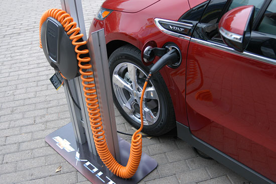
More than 100 new chargers will be online by this time next year.
Step away from that gas tank, Southern California commuters, and prepare for a jolt of good news: By this time next year, Los Angeles County will have more than 100 new charging stations for plug-in hybrid and electric vehicles.
Last month, Metro announced that five park and ride stations would each soon be installing four Level 2 chargers, enough to accommodate about eight vehicles per station at any given time.
Now the Los Angeles County Board of Supervisors has set the stage for 93 more stations around the county, approving grants and funding this week for public chargers at 40 more sites from the Music Center to county hospitals.
Tom Tindall, director of the county’s Internal Services Department, says the move will not only help shrink the county’s carbon footprint, but also responds to a growing demand among plug-in and EV owners for places to recharge. Though alternative vehicles have been slow to catch on among commuters in some parts of the country, Southern California’s malls and parking garages have been increasingly jammed with drivers of all-electric vehicles known as EVs (the Nissan Leaf, for example) and plug-in hybrids (such as the Chevrolet Volt or Toyota’s plug-in Prius) competing for too few outlets. (Both types of vehicles need to be plugged in, but EVs are strictly electric while plug-ins have a combustion engine as well as a battery that runs on electricity.) Some automotive bloggers are even reporting that “charging congestion” here has begun to replace “range anxiety” as the chief downside of going electric.
“More than a third of the EVs in the United States are registered in California, and over 40 percent of all the plug-in EVs sold in California are registered in Southern California Edison’s territory,” says Tindall. “This will provide charging areas that are convenient for both the public and county employees.”
Marie Nuñez, who oversees parking and fleet operations for ISD, says the new stations will begin opening in August, with the rollout complete by the end of the year. Some of the new stations will replace old and long-since decommissioned chargers at county garages, she says, but most will be new additions capable of charging up to two vehicles at one time. Locations will be released to web sites that list charging locations as they become available.
“We’re going to replace the three old-style chargers at the Music Center,” she says, “and we’re going to put four in at Walt Disney Hall. The county Arboretum and the Department of Public Works will each have three for the public. Lot 10 under Grand Park will get four chargers. The county hospitals will all get two to four chargers each, and the beaches at Marina Del Rey and Playa Del Rey will each get two. There should be enough to charge at least 150 cars at any given time.”
All will be outfitted with standard connections to accommodate the increasing numbers of Volts, Priuses, Leafs and other EVs and plug-ins being used by the public and the county fleet, says Nuñez, adding that 80 percent of the $384,687 cost of purchase and installation will be offset by two grants.
The rest of the outlay will come from existing budgets at participating county departments, which will pay a net cost of $778 per station. Ordinarily, Nuñez adds, commercial chargers cost about $4,000 each.
Nuñez says drivers can expect to be charged a nominal fee to cover the cost of electricity and maintenance, though details are still being worked out. Payment may be by credit card or smart phone, or may follow a subscription model similar to the one Metro is trying. Under that method, an hour of charging costs about $1.
Tindall expects the new stations to be popular with county employees as well as the public. “These are way stations for commuters, too,” he says.
As it is, he laughs, the alternative crowd has been making its needs known: “I’ve seen Volts parked in a couple of garages where people have plugged them in with extension cords.”
Posted 3/7/13
Solving the whodunit of Topanga Beach
January 8, 2013
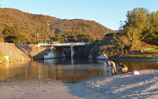
Scientists from UCLA and Santa Monica Mountains Resource Conservation District take samples from the Topanga Lagoon. Photo/Rosi Dagit
It has been a mystery now for almost a decade: What’s polluting the water at Topanga State Beach?
Once regarded as one of the cleanest stretches of ocean in Los Angeles County, Topanga fell from grace around 2003, when high bacteria levels sank its water quality score on Heal the Bay’s annual Beach Report Card.
Although cleanup efforts were diligent, testing methods couldn’t pinpoint the source of the problem. Theories abounded. Was it someone’s leaky septic system? Birds and coyotes? Illegal dumping upstream in Topanga Creek?
“We thought it might be the old septic system at the public restrooms,” says Rosi Dagit, senior conservation biologist for the Santa Monica Mountains Resource Conservation District. “So that was redone and replaced with a state-of-the-art system. Then we thought it might be the old septic systems in the rodeo grounds upstream from the lagoon, so those were removed, too.”
But the problem remained. “We kept taking out potential sources of bacteria,” Dagit says, “and the beach kept getting these high numbers.” Consequently, even though other types of pollution are markedly low at Topanga, the beach has been more or less a regular on Heal the Bay’s official “Beach Bummers” 10-worst-beaches list.
Now Topanga Beach has become the focus of an in-depth study that will seek to finally nail down the reason behind the chronically high levels of total coliform, fecal coliform and enterococcus bacteria, which may make swimmers sick.
Piggybacking on a larger statewide look at beach pollution hotspots that began in 2010, the new, two-year look at Topanga, which began in November, will sample water up to twice monthly from as many as 10 locations on Topanga State Beach and along the lower section of the creek that feeds the lagoon there. The samples then will be subjected to rigorous DNA testing.
The study also will examine the connection between tiny invertebrates and nutrient levels in the water, along with why the generally normal bacteria levels in the creek tend to spike when the water hits the lagoon and ocean, says Dagit. There’ll also be an educational component, with opportunities for school children to visit the testing labs at UCLA and learn how to help keep Southern California’s water clean.
The added scrutiny—expected to cost $550,000 during the study’s two years—is being funded through an allocation from the office of Los Angeles County Supervisor Zev Yaroslavsky. The Topanga effort is being jointly overseen by UCLA, which is a local lead on the statewide study, and the Resource Conservation District. Dagit, the county’s point-person on the project, says the tests are complex and relatively new.
“You have to collect the samples before sunlight hits the water,” she says, “because the sun makes bacteria go crazy. So we’ve been getting up at night and going down to the water before sun-up. Our last sampling was December 19, and let me tell you, it was cold.”
The tests also are expensive—about $200 per half-gallon water sample—but have come down markedly in cost over the past few years.
Scientists are enthusiastic about the study’s prospects.
“It’s like DNA fingerprinting of bacteria,” says Dagit. “We’ll be able to find out not only whether the source is human or non-human, but if it’s non-human, whether it’s from gulls, dogs, coyotes or horses and whether it came from a direct deposit on the beach, or from gray water or a septic system.”
That’s important, she says, because bacteria from a natural source, such as wildlife, requires a different set of solutions than does bacteria from the feces of pets and humans. “Suppose those bacteria levels are because of a lot of gulls roosting at Topanga Lagoon,” Dagit says. “We don’t want people swimming in water with high bacterial levels, but we don’t want to get rid of the gulls.”
Dagit says that, by this time next year, scientists should have many more clues to the mystery at Topanga Beach.
“It should be pretty amazing,” she says. “We haven’t really had the technology to do this kind of study until now.”
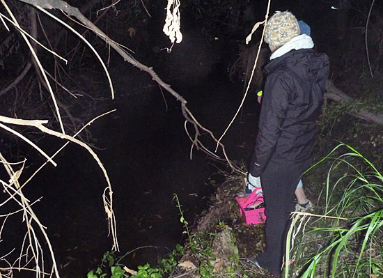
UCLA grad student Amy Zimmer-Faust and Senior Conservation Biologist Rosi Dagit collect bacteria samples by night in Topanga Creek. Photo/Tim Riedel
Posted 1/2/13
Storming the beach as runoff flows
December 6, 2012
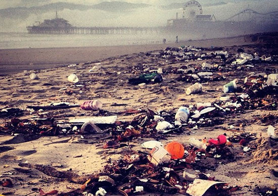
One local beach after last weekend's rain storms. Photo/Ana Luisa Ahern for Heal the Bay
The first storm of a Southern California winter can be welcome and even romantic. Not so the aftermath—or as clean-up crews at the beach wryly call it, “The First Flush.”
“Those big storms really clean out the creeks and the catch basins,” says Carlos Zimmerman, assistant chief in the facilities and property maintenance division at the county Department of Beaches & Harbors, and a 33-year employee of the department. “Everything washes down—trees, bushes, firewood, plastic bottles, foam containers. Tons and tons of trash. Dead dogs and cats. Snakes. All kinds of things, you wouldn’t believe it. I saw a BMW come out of Topanga Creek once.”
That’s why, as rainstorms pelted Southern California last weekend, county and municipal crews were hitting the beaches to clean up debris. Their efforts are just one of the ways—from pending litigation to an upcoming Clean Water, Clean Beaches ballot measure—in which runoff will be front and center this winter in Los Angeles County
“Things like education efforts and ordinances against single-use plastic bags and polystyrene containers are making inroads, but it’s obviously an extreme problem,” notes Kirsten James, water quality director at Heal the Bay, the environmental advocacy organization.
Debris, she notes, is just the most visible pollution that courses into the ocean after a rainstorm. (This is one reason why health officials recommend staying out of the ocean for 72 hours after a rainstorm.)
“Heavy metals and bacteria are in there as well,” James says. “Some years, [the First Flush] looks like you’re not even in a First World country—more like you’re at a dump than at the beach.”
Kerry Silverstrom, chief deputy director at Beaches & Harbors, says that county beaches get runoff from more than 200 storm drains, as well as from Ballona Creek, which dumps runoff from miles inland into Santa Monica Bay. Though “trash catchers” installed throughout the system in recent years are intercepting more and more garbage, some still is making it down to the shoreline. Because storm water often continues to flow long after a heavy rainfall, and the debris it carries can churn on the waves for days before being washed up by high tide, the cleanup after a storm usually lasts long after the clouds part.
“That was one of the surprises when I first came to Beaches & Harbors,” says Silverstrom. “I had no idea that there was as much winter work on the beaches as summer work.”
That winter work, done by year-round maintenance crews, can mean anything from tending beach restrooms to piling sandbags to pulling lifeguard towers back from the pounding surf. Kenneth Foreman, chief of the department’s facilities and property maintenance division, says nearly 80 county workers were deployed at a dozen coastal beaches after last weekend’s rain storms, from equipment operators with sand-sanitizing machinery to hand crews who walked the high-tide line, plucking scraps of litter.
The winter crews, he adds, start at 6 a.m. and work every day, rain or shine, including weekends. “We worked Saturday and Sunday, even though it was storming,” he says. “Often by the time the general public hits the beach, they have no idea how dirty it was before they got there.”
There are things the public can do to help limit beach pollution, from proper disposal of motor oil and animal waste to keeping trash out of the storm drains to letting local stormwater coordinators know if flooding occurs in your neighborhood from trash-clogged catch basins.
On a longer-term level, the Board of Supervisors will conduct a January 15 public hearing on whether to seek property owner approval of the Clean Water, Clean Beaches measure through a mail-in ballot. The measure, prompted in part by toughened federal clean water standards, would raise $270 million for stormwater projects in Los Angeles County by assessing parcel owners based on the amount of runoff they generate (about $54 a year for a typical single-family residence.)
Meanwhile, cleanup crews will be fighting the good fight on a landscape that, when the storms hit, still too often becomes long on odor and short on scenery. At a Santa Monica city beach near the Pico/Kenter storm drain, a Heal the Bay staffer blogged last Friday morning that the sight and stench were “shocking.”
“I . . . saw runoff flowing fast out onto the Santa Monica beach, carrying along with it strong smells reminiscent of motor oil and gasoline, hundreds of plastic cups, chip bags, soda cans, an unusually high number of tennis balls, plastic bags (some full of pet waste), bits of Styrofoam, bottle caps, and more urban detritus,” blogged interactive campaigns manager Ana Luisa Ahern, who posted some haunting pre-cleanup photos on the organization’s web site.
“It was a saddening and somber sight, to say the least.”
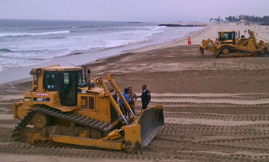
Kenneth Foreman Sr. of Beaches & Harbors, in jacket at far right, hits the sand after last weekend's storms.
Posted 12/6/12


 405 bridge work causes a stink