


Top Story: Environment
Fault findings break new ground
October 21, 2011
 Years before the first trains roll, the Westside Subway is already getting somewhere—at least when it comes to seismic discoveries.
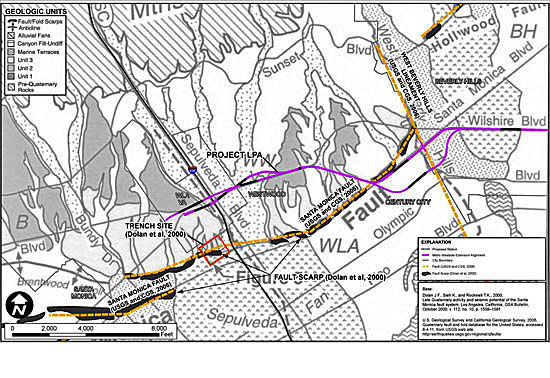
Earthquake geologist James Dolan, a USC earth sciences professor and consultant to the transit project, this week presented findings that pinpoint the location—and active seismic status—of a formation known as the West Beverly Hills Lineament.
Remember that name.
It turns out the WBHL, as it’s known, is a branch of the mighty Newport-Inglewood Fault, an active and powerful system stretching from Culver City to Newport Beach and continuing south through San Diego and into Mexico’s Baja peninsula.
Dolan led the research team that first came across the formation and named it in the early 1990s. But it was only in recent months that intensive research to determine the safest site for the subway’s Century City station helped the geologist “confirm our earlier inferences that the West Beverly Hills Lineament is the northernmost part of the Newport-Inglewood Fault System.”
In the world of seismology, that’s a big deal. The Newport-Inglewood system is a giant and has been active during the Holocene era (i.e., the last 11,000 years), most notably in 1933, when it caused an earthquake in Long Beach that killed some 120 people, making it the second deadliest in California history, after the great San Francisco earthquake of 1906.
The presence of the WBHL and the nearby Santa Monica fault, which is also active, make it too dangerous to build a Santa Monica Boulevardstation for the new subway in Century City, Dolan and other scientists told a Metro committee Wednesday. They said that another proposed location for the station—at Constellation Boulevard and Avenue of the Stars—was a better option because it showed no evidence of earthquake faults.
The state has recognized the WBHL and the Santa Monica Fault as active fault zones on its maps, Dolan said, but does not yet classify them as such under the Alquist-Priolo Earthquake Fault Zoning Act, which imposes building restrictions in such areas. Data like those acquired during the recent research are the kind of information needed to eventually place such active fault zones under Alquist-Priolo regulations, Dolan said.
“As a scientist, it’s very exciting,” said Lucy Jones of the U.S. Geologic Survey and Caltech, who reviewed the research as part of an independent review panel. “Knowing that the Newport-Inglewood Fault is active this far north is new,” she said, later adding that the finding is “of significant import for the city of Los Angeles.”
The WBHL extends north-northwest from Culver City through West L.A., bisecting west Beverly Hills and east Century City, traversing Constellation andSanta Monica boulevards between Moreno Drive and Century Park East before ending roughly at Sunset Boulevard.
A “major event” on the WBHL could mean an earthquake ranging in magnitude from 6.4 to 7.2, along with ground movement of three to six feet, according to an executive summary of the experts’ findings.
While it’s not possible to predict when a given fault might slip, it’s prudent to take the potential impact seriously, Dolan told the committee:
“Earthquakes don’t typically recur on our kind of human lifetime scales,” Dolan said. “That doesn’t mean that we can disregard the risk associated with these things. It very well may be it will be 3,000 years until we have an earthquake on the Santa Monica Fault. Then again, it could happen tomorrow. It depends on whether you’re a betting person, I guess.”
While acknowledging that such discoveries can spark concerns, Dolan said in an interview that he prefers to take an all-news-is-good-news approach.
“I think anything we learn about active faults in L.A.is always good news,” he said, “because it’s absolutely critical that we fully understand the seismic threat facing us as residents of earthquake country.”
Members of the Metro committee listened attentively during Dolan’s presentation (and one, Richard Katz, asked him to slow down at one point so he could take in the rush of information.)
Supervisor Zev Yaroslavsky, another committee member, said he was so engrossed with Dolan’s style of scientific explanation that it might once have set him on a different career path.
“If I’d first met him 40 years ago, I would have been a geology major,” Yaroslavsky said.
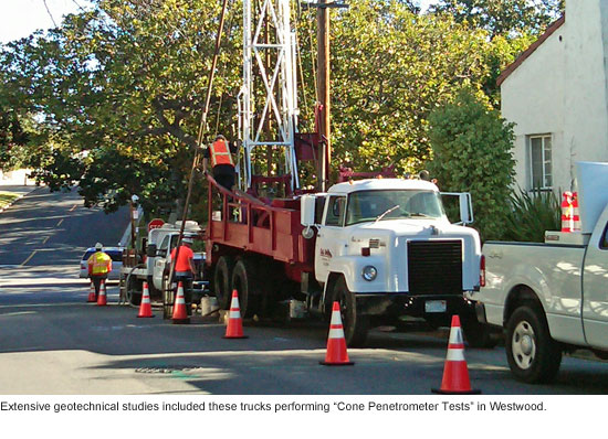
Dolan, an expert on urban faults and the seismic hazards underlying the metropolitan Los Angelesarea, said the latest round of extensive research gave him a chance to catch up with his unfinished business with the WBHL. “These data have been a wonderful validation of our earlier research,” he said. “They’ve greatly fleshed out the details of these faults. Those details are the critical information we need.”
At the committee meeting, he spoke enthusiastically about the exhaustive testing that helped unearth those details, including “cone pentetrometer” tests and “seismic reflection profiles” (“It’s like a CAT scan of the earth,” Dolan explained to the committee.)
After it was all over, the committee chair, Diane DuBois, paid Dolan and the other scientific experts the ultimate layperson’s compliment on their presentation:
“I even understood it,” she said.
Posted 10/20/11
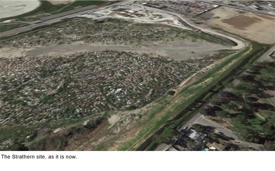
From pit to park
September 14, 2011
It’s not much to look at now. But when Sun Valley’s Strathern Pit is reborn as the Strathern Wetlands Park, the new facility is expected to offer picnic spots, walking trails, basketball and tennis courts, an exercise station, wildlife habitat and landscaped ponds.
Those water features aren’t just ornamental—they are being designed to play an important role in diverting and treating storm water runoff.
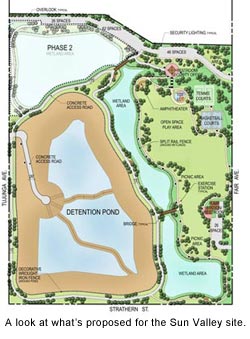 The multifaceted approach promises to bring beauty and usefulness to the 46-acre site, which until 2009 was used as a construction debris landfill.
The park’s proposed recreational features were developed at a community workshop in April. Get a look at what’s being planned at a community meeting this Saturday, September 17, at the Richard E. Byrd Middle School Auditorium, 8501 Arleta Avenue in Sun Valley. The meeting runs from 10 a.m. until 1 p.m. Reservations aren’t required but if you’d like to RSVP, you can do so by contacting project manager Mark Lombos at (626) 458-7143 or by emailing [email protected].
Construction on the wetlands park is expected to begin in the fall of 2013. The $50 million project is being funded by the Los Angeles County Flood Control District, City of Los Angeles Proposition O and the City of Los Angeles Department of Water and Power.
Posted 9/13/11
Seeing the forest and the trees
August 25, 2011
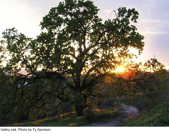
Few living things are as integral to Los Angeles as its mighty oak woodlands. They fed wooly mammoths and sheltered Native American tribes.
They’ve supported thousands of species of birds, mammals, reptiles and insects. They were remarked upon in the 1769 diaries of the awestruck Franciscan missionary, Father Juan Crespi. Even now, scattered though they may seem, they inspire reverence, rising from the chaparral like ghosts of another California. Unfortunately, as much as 80% of Los Angeles County’s original oak woodlands have been destroyed.
For the last several decades, environmentalists have waged an uphill battle to preserve the county’s 145,000 remaining acres of oak woodlands. Their successes have included a 1982 county ordinance that has made it difficult to cut down mature oak trees.
Still, the existing law is oriented toward regulating the removal of individual oak trees rather than preserving an entire ecosystem. As a result, while single trees enjoy some protection, the woodlands themselves—which filter pollution, absorb carbon dioxide, anchor stream banks and hillsides and slow floodwaters—remain vulnerable to everything from development to falling water tables. So on Tuesday, the Board of Supervisors took a step toward not only conserving L.A.’s beloved native species, but also toward making it easier for individual property owners to voluntarily do the right thing.
“The purpose of this is partly to raise the profile of this important ecosystem,” says Rosi Dagit, a senior conservation biologist at the Santa Monica Mountains Resource Conservation District who for the past three years has coordinated a strategic alliance of environmentalists, foresters, arborists, building industry representatives, fire officials and other interested parties in developing an oak woodlands management plan.
The group’s report offers two sets of recommendations. The first set, adopted by the Board on Tuesday, includes maps and a conservation strategy that make the county eligible for state woodlands conservation money that, in turn, will help buy land for public trusts and conservation easements.
The report also suggests ways that private property owners—who still control a quarter of the county’s woodlands in large tracts such as Newhall Ranchand small communities such as Topanga Canyon and Monte Nido—can voluntarily help preserve them by, for instance, donating land and easements themselves, thus reaping income, property and estate tax breaks.
The second set of recommendations, which was sent to staff for a report in six months on its potential for implementation, includes ways to incorporate oak woodland conservation into the general plan and important guidelines for such things as assigning a dollar value to a tree’s importance in mitigating global warming or as a source of flood control. It also includes a number of revisions to the existing oak tree ordinance.
For instance, Dagit says, under existing rules, property owners dread oak trees almost as much as they love them because they are required to pay for a pricey permit to cut one down after it reaches more than 8 inches in diameter.
“It’s several hundred dollars just for the permit,” she says, “and then you have to pay an arborist to do an oak tree report, which is several hundred more, and then if it’s more than one tree, you have to pay for a hearing, which can cost thousands of dollars. So typically, if a little oak tree volunteers in their yard, a lot of people don’t want the hassle—before it can reach 8 inches, they take it out.”
This is problematic, she says, because oak trees bind Los Angeles in more ways than Angelenos realize, from securing the soil and creating drainage to mitigating the city’s carbon footprint. “Each mature oak tree takes out nine tons of carbon a year,” says Dagit, “so we want to plant them, even if they’re only going to be around for 10 or 15 years.”
Under the proposed recommendations, property owners who might love to have a stand of oak trees but fear the potential for bureaucratic problems can head off future costs by planting trees themselves and providing a map (even a hand-drawn one) to the county.
“Then, ten years later, if you wanted to take out one of those oaks to put in a tennis court or whatever, you could do what you needed to do without a penalty,” says Dagit. “And meanwhile, the public will have reaped the benefit.”
This, she says, would be especially helpful in places like landfills, where oaks would be the perfect ground cover were it not for the owners’ fear of future impediments should a need to, say, get to some piping, require them to tear out a tree.
Dagit stresses that the current report is intended to make conservation easier, not harder: “We want to provide incentives for people so oaks won’t be considered a liability.”
But, she says, the woodlands continue to dwindle, and so far, not one section of oak woodland has been fully restored or recovered. “Trees are the background assumption of our life,” she says.
“People look out the window and think that the trees will always be there. But will they be?”
Posted 8/25/11
Good start for new L.A. River project
July 13, 2011
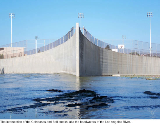 Weedy and industrial, the concrete channel near the football field at Canoga Park High School scarcely looks like a notable site.
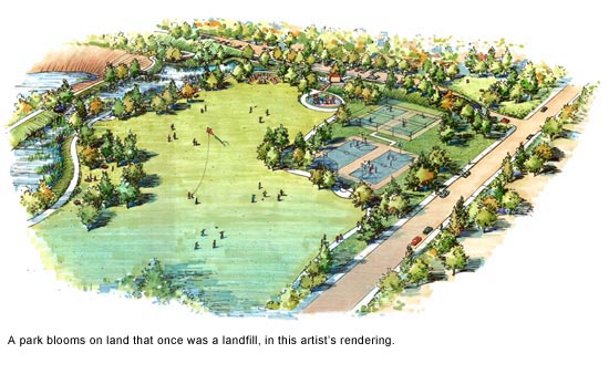
But the spot where Calabasas Creek meets Bell Creek—be it ever so humble—is actually a landmark: the beginning of the Los Angeles River. And this week, it came a big step closer to getting the kind of makeover that would allow it to finally shine.
The Board of Supervisors accepted a $1.97 million state grant to help launch construction of the Los Angeles River Headwaters Project, which eventually will create more than a mile of recreational trails at the point where the storied urban river starts near Canoga Park High School in the San Fernando Valley.
Tentatively scheduled for completion in 2013, the Headwaters Project is part of a larger plan to reclaim and revitalize the river, which runs for some 50 miles through 13 cities, including Los Angeles, before it empties into the ocean at Long Beach. (Click here for an artist’s rendering of the project.)
The grant, authorized under the Proposition 84 state park program and awarded by the California Natural Resources Agency, will be a substantial down-payment on the headwaters improvement, which is expected to add some $9.3 million worth of pedestrian paths, landscaping, signage, water quality improvements and decorative fencing to an area now closed to the public and mostly used for flood control and maintenance.
Officials from the county Department of Public Works say it is the first of several grants for which they’ve applied in the hope of mitigating the cost of the project. And, they note, the City of Los Angeles has applied for an additional Metropolitan Transportation Authority grant to add a bike path to the area.
“Right now, it doesn’t look like a place anyone would want to visit,” says Terri Grant, principal engineer for the county Department of Public Works.
“But when it’s done, it will enhance the community, and draw people to a new area of open space where they can enjoy themselves and relax.”
Posted 7/13/11
Horseplay at the aquarium
May 25, 2011
 You dads out there might be feeling pretty good about yourselves with Father’s Day just around the corner. But sorry, Pops, the seahorse has you beat.
The male seahorse is so devoted that he carries as many as 1,000 offspring deposited by the mom in a brood pouch for 14 days, until they hatch. At that point, with the fry fully formed, the father is pretty much done with parenting chores. But for those two weeks, he’s as attentive as they come.
The seahorse, like the giant panda on land, is one of those iconic creatures that seem to naturally capture our affection and pique our curiosity. Maybe it’s the odd shape, maybe it’s that comic snout they use to suck in food, who knows? It’s hard to even remember they’re fish.
For Randi Parent of the Santa Monica Pier Aquarium, the attraction of seahorses is in the way they move.
“They kind of have that vertical thing going for them,” she said. “Their locomotion is just so different from other marine animals – it’s captivating.”
Also like the giant panda, these creatures, especially the native Pacific seahorse, can serve as a symbol for conservation efforts.
“Pacific seahorses live close to the shore in tall marine grasses,” said aquarium Director Vicki Wawerchak, “which makes them very susceptible to coastal development and subject to capture and overfishing. Never buy dried seahorses at novelty shops.”
Why buy a lousy dried one, anyway, when you can see a whole herd of them live at Santa Monica Pier Aquarium’s new exhibit? The Pacific seahorse featured in the exhibit grows up to 12 inches and is the only species found along California’s coast.
As part of a special aquarium promotion, seahorses are also available for “aquadoption” at a cost of $50 (it goes to $250 after July 1). Adoptive parents make an investment in the animal’s care and, in return, receive an adoption certificate photo, free aquarium passes and a year’s membership to Heal the Bay, along with the satisfaction of contributing to the preservation of marine life.
More than 100 other species are also on display at the Aquarium, which is Heal the Bay’s forum for educating the public about marine life. Heal the Bay is a nonprofit organization whose mission is to keep coastal waters and watersheds of SoCal clean and safe.
The exhibit opens this Saturday, May 28. Aquarium hours are 2 p.m. to 6 p.m. Monday through Friday, and 12:30 p.m. to 6 p.m. on the weekends. There is a suggested donation of $5 for admission (or a $3 minimum entry fee). Kids 12 and under get in free. The Aquarium is located at the beach level of the Santa Monica Pier, 1600 Ocean Front Walk.
Posted 5/25/11
Green day for energy makeover winners
May 18, 2011
Short of a visit from Ty Pennington, it’s the ultimate homeowner’s daydream: $10,000 or even $50,000 to bring the old place up to date.
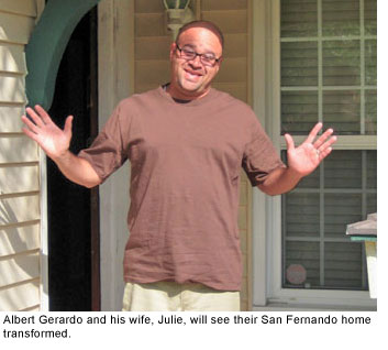
In the case of six lucky Los Angeles County families, just such a windfall is headed their way. But don’t turn green with envy—because these environmentally-friendly home improvement projects are meant to benefit everybody.
Winners were announced today in the Home Energy Makeover Contest sponsored by Energy Upgrade California, an alliance among L.A. County, local cities, Southern California Edison and the Southern California Gas Company.
The $50,000 Grand Prize makeover went to the Gerardo family of San Fernando, whose 1953 one-story home will be transformed into a “near zero energy house.” (Which means that this prize will be a gift that keeps on giving as far as future energy bills are concerned.)
The upgrades to the Gerardo home will range from solving ventilation and insulation problems to replacing their antiquated swimming pool pump.
The other makeover prizes, worth $10,000 each, went to families in Encino, LaVerne, Pomona, Baldwin Hills and Whittier.
Meet the Gerardos and the other winners here.
More than 1,425 homeowners entered the contest, which is meant to inspire all of us to get with the energy-saving program. (You can start your own action plan here.)
Posted 5/12/11
Voyage to the center of the Earth Day
April 21, 2011

This weekend, you may hear the rumble and hoot of a distant drum circle inviting you to Topanga Earth Day.
Heed the call and you’ll find yourself transported to Los Angeles County’s Earth Day epicenter as Topanga Canyon lives up to its nature-centric reputation and throws a planet-loving bash to remember.
Where else on the planet, after all, can you spend a weekend building a tipi, making a seed ball, dropping by a Healing Arts Tent, listening to the Grateful Dead’s drummer and sipping some locally-produced wine—all in a one-of-a-kind community that’s just miles from Hollywood and the Westside on the map but a galaxy away in spirit?
Topanga’s annual holiday celebration began in 2000, as locals celebrated after a volunteer cleanup of Topanga Creek. Now the full-fledged festival lasts all weekend and includes musical acts from across the globe. The creek is so pristine that it doesn’t need cleaning this year, so the volunteers have shifted their focus to local beaches instead.
 Many Topangans view themselves as stewards of the land, dutifully repaying the earth for the magic and majesty it bestows upon them in the form of fabled creeks and craggy mountains. Darkened by the canyon and a dearth of streetlights, it’s one of the rare places close to the city where you can still clearly see the night stars.
“We are surrounded by 200 square miles of state park,” notes Stephanie Lallouz, organizer of Topanga Earth Day. “Because of that, most of us in the community are pretty in tune with nature. We drive slower to protect the coyotes and bobcats.”
A bohemian spirit and ‘60s ethos lingers on in a place where folks like Joni Mitchell, Jim Morrison, Neil Young, and Marvin Gaye once lived, played or made music. And Earth Day 2011 seems a fine time to discover what they—and Topanga’s current eclectic crop of residents—have long known about this particular place in the sun.
The celebration begins Friday, April 22 from 7-10 p.m. with an eco-art show opening, wine tasting, and jazz. The main event is Saturday and Sunday, and it lasts from 10 a.m. to sunset both days. There will be music, speakers, workshops, a children’s activity area, and plenty more.
Organizers take pride in the multicultural nature of the jubilee, so you can expect to find many parts of the planet represented. Musical acts hail from places like Africa, Florida, Japan, Jamaica, Israel, Jordan and India, to name a few. (Bill Kreutzman, original drummer for Grateful Dead, is also expected to make an appearance.)
Planned festivities are educational (learn to “plant native,” compost, and use earth-friendly technology), entertaining (a band that uses a 30-foot string setup, belly dancers, and wine tasting), service-oriented (beach clean-up, tree planting), creative (recycled art, flag painting), and esoteric (chanting, reiki).
You can make seed balls and learn ways to conserve water. You also can practice yoga in the morning, have an organic vegetarian lunch, and participate in a sacred Japanese tea ceremony. Along the way, learn to build a tipi and participate in a guided philosophical discussion inside of it.
For a full rundown of activities, visit the Topanga Earth Day website.
For entry, there’s a $12 suggested donation. Eco-friendly non-profit organizations will receive 60% of the proceeds, with the remaining 40% going towards next year’s event. This year’s beneficiaries include Doctors Without Borders, Sea Shepherd and the Topanga Community Club.
The event is sponsored by diverse community, government, and business groups, who will host booths with their own offerings. L.A. County Department of Public Works’ Waterworks program will be on hand with free giveaways as they educate the public on methods of water conservation.
If you go, keep the health of the planet in mind. Rideshare to designated parking locations along Topanga Canyon Boulevard, then bike, hike, or take the free BioDiesel Shuttle up to the festival at the Topanga Community Club Fair Grounds, 1440 N. Topanga Blvd., Topanga, CA 90290.

Posted 4/21/11
Are our clean beaches endangered?
April 13, 2011
 Spring may have just arrived but folks in the Department of Beaches and Harbors have already got summer on their mind.
They’re scrambling to figure out how to maintain the county’s beaches and restrooms during the oncoming peak season after losing more than two dozen staffers who’d been hired with federal stimulus funds that are no longer available. At the same time, the department, like others in the county, cannot backfill for vacancies.
The impact, said LA County Department of Beaches and Harbors’ Chief Deputy Director Kerry Silverstrom, is unlikely to escape the public.
“We have an international reputation for clean beaches,” she said. “That will probably change.”
Beginning May 1, the Beaches and Harbors Department says it will consolidate last summer’s three overlapping shifts into just one, with the primary focus being to keep the beaches and restrooms clean during peak attendance. This means that, at some beaches, there’ll be no maintenance staff during early morning and evening hours.
With fewer workers, some previously performed maintenance will inevitably suffer, beach officials acknowledged. That includes large debris removal, weed abatement and even replacing damaged volleyball nets. But beach officials stressed that the financial situation is fluid and that they can’t say for sure exactly what services will be most impacted.
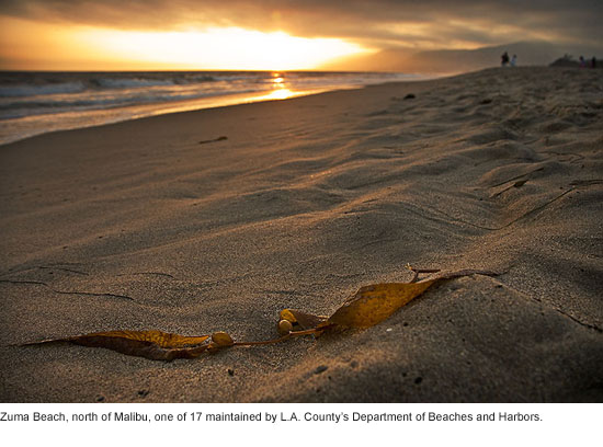
The Department of Beaches and Harbors—which maintains 17 beaches across 25 miles of coastline, with 52 bathrooms and 36 parking lots—first announced changes in bathroom service hours in a statement on Monday, saying “some restrooms may not be opened and serviced until as late as 11:00 a.m. year-round.”
Some news outlets followed up with stories in which they reported that bathrooms might be closed for days. This prompted irate phone calls from the public. The department responded on Facebook by saying that there will be no closures during the summer season and that the changes in hours would “allow limited staff to provide restroom cleaning later into the afternoon when beach usage is heaviest.”
Silverstrom said that both the frequency and intensity of cleanings would suffer because of the reduced numbers of maintenance workers, especially later in the day. Previously, all restrooms were opened by 6 a.m. But tentative plans now call for opening some at around 8 a.m. and others not until about 11 a.m.
Department officials said they do not yet know how many restrooms would be impacted but stressed that the most crowded would get the most attention. The use of portable toilets has been suggested but Silverstrom said she believes this could cause consternation among residents and beachgoers.
Aside from bathrooms, beachgoers will likely notice other issues stemming from the reduction in staff, including parking.
Maintenance staff has been responsible for opening and closing the lots in years prior. Now that they’ll be reporting 2 hours later to their shifts, Beaches and Harbors is trying to figure out how to still get the lots opened early and closed late. Some lots, including a dozen at Zuma Beach, will not be affected because early-arriving power equipment operators will open them. Officials are still determining how to get them locked up at night.
The department said it will also make sure that 5 lots identified as among the county’s most popular will also be opened at 6 a.m. Under one tentative plan, another 6 lots in relatively safe locations would be kept open around the clock. At least one lot, at Nicholas Beach, will open later in the day.
All these challenges are exacerbated, of course, by the consistently large draw of the county’s beaches. Last year was considered a “bad weather year” for LA County beaches. Still, Silverstrom estimates that 60 million visitors came to play in the sand and surf—10 million more than in 2008.
The department said it will continue to update the public through its Facebook and Twitter pages.
Posted 4/7/11
A hike with a view
February 24, 2011
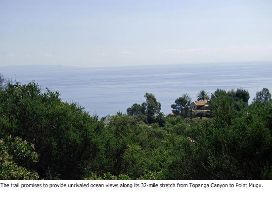
For more than a quarter-century, Southern California hikers have dreamed of a trail that would offer the mother of all vistas, a 32-mile ocean-view trek between Topanga Canyon and Point Mugu.
Backpackers could, say, hike up the coast, uninterrupted by “No Trespassing” signs and fences, enjoying an ocean breeze while treading through virgin chaparral and fragrant canyons. At night, they could pitch a tent on a Malibu bluff and awaken at dawn with the blue Pacific heaving and roaring below.
The Coastal Slope Trail has been part of the Los Angeles County Trails Master Plan since the early 1980s, with occasional controversy and little progress. But now, bit by bit, the dream is coming true, despite some continuing dust-ups along the way.
Late last year, the California Coastal Commission approved a plan that included the trail, restrooms, parking and the first-ever public camping within the Malibu city limits, approval of which has been challenged by the city and a homeowner’s group. And just this month, the Mountains Recreation and Conservation Authority—a joint powers authority that includes the Santa Monica Mountains Conservancy and a number of park districts—announced the acquisition of several pieces of land along the Carbon Canyon section of the proposed trail site.
The acquisitions, north of Malibu, will not only mark the first public open space in Carbon Canyon, but will begin to connect the disparate parks and public lands that now dot the Los Angeles County coastline like gems in a half-made necklace.
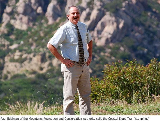
So far, the acquisitions represent only eight of the roughly hundred parcels needed to bring the trail to completion. But Paul Edelman, the authority’s chief of natural resources and planning, says they’re “a significant momentum gainer.”
The authority, he says, is poised to acquire up to eight more properties along the trail in 2011, and is hoping to finish most of the Los Angeles County portion within the next couple of years if funding and public support hold steady. To date, Edelman says, 64% of the property needed to accommodate the Slope Trail is in public hands.
The completed trail would link at least 15 distinct public spaces, ranging in size from 15,000 acres to two acres. They include the state parks at Topanga, Malibu Creek, Leo Carrillo and Point Mugu, as well as the City of Malibu’s Charmlee Park.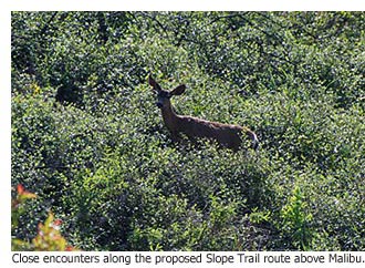
“People like to go to these areas—there’s a real pent-up demand,” says Edelman. But hiking from one to another is next to impossible. Some spots are fenced off; others are too steep and rugged even if hikers were daring enough to trespass.
But with the generosity of some landowners and the help of Proposition A park and open space funds, the land between them is being appraised, acquired and turned into connective tissue. “This will be the public’s chance to access these areas without having to tramp through private property or tick-infested bushes,” Edelman says.
The largest gap right now, he said, is a steep, 4-mile stretch between Point Mugu and Leo Carrillo state parks that’s owned by the Mansdorf Family Trust, which grew from the storied estate of an aviation entrepreneur. The smallest is a quarter-mile gap between Solstice and Latigo Canyons that for decades was used as a horse trail, but is now fenced. It is owned by the famed U2 lead guitarist The Edge.
No easements have been offered through either of those parcels, Edelman says.
In Carbon Canyon, where much of the land near the trail is too steep, rugged and fire-prone to be useful, Edelman said a dentist from Northern California donated a 2.5-acre parcel of chaparral, and a “former Fortune 500 guy who wanted to remain anonymous” donated the 3-acre plot next door. A third property owner agreed to sell the authority an adjacent easement for $480,000. “The guy was British and had an understanding of the importance of public land,” says Edelman. “He had this sense of duty to make sure there was a public right of way.”
That stretch of land, he says, will now be the start of a bridge between Tuna Canyon Park and Sweetwater Mesa, where the authority has a 24-acre plot.
“People don’t even think about what will be visible when we finish this project,” says Edelman. “The beautiful back ridge line of Carbon Canyon. Some of the coolest rock formations in the Santa Monica Mountains—maybe the coolest. Higher up, you’ll be able to see all the way to Malibu Point, all the islands. Stunning.”
 Posted 2/24/11


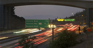
 405 bridge work causes a stink